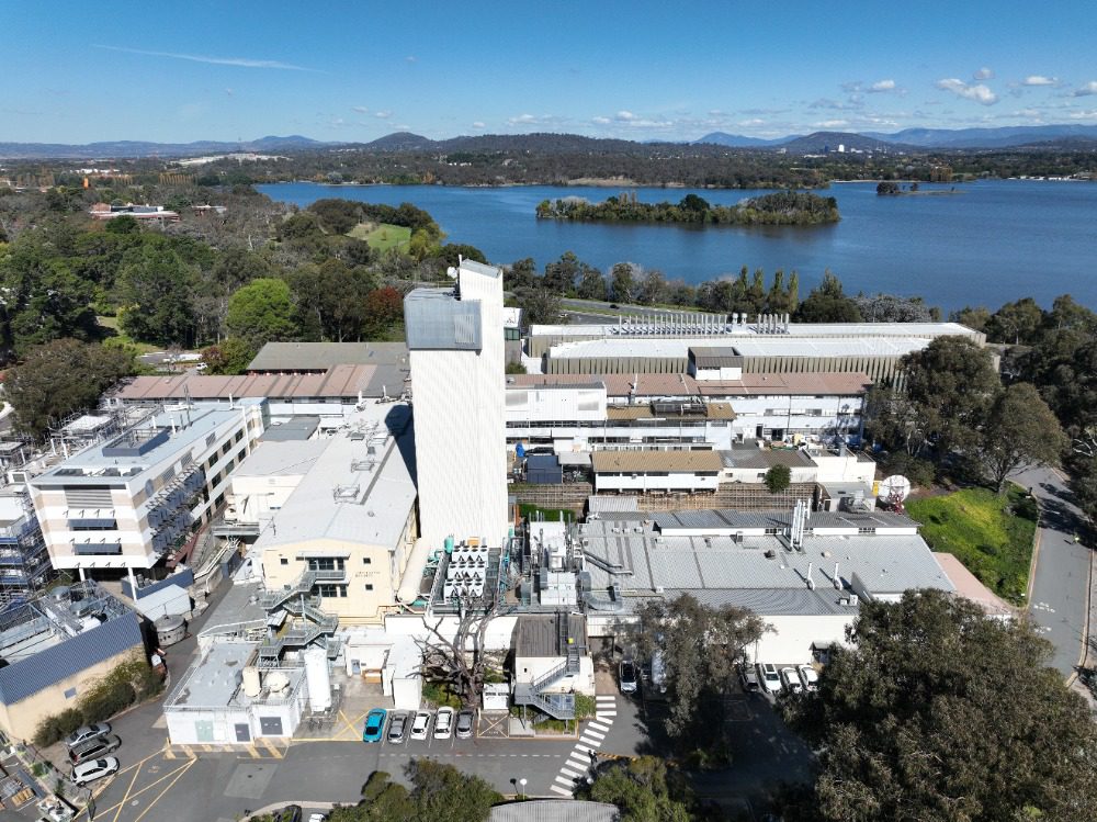
Drone Roof & Facade Inspection – Australian National University Canberra
High Exposure was engaged by the main contractor overseeing the remedial repairs of Australian National University in Canberra to assist with assessing damages to a
Aerial imagery and survey solutions for the built and natural environment


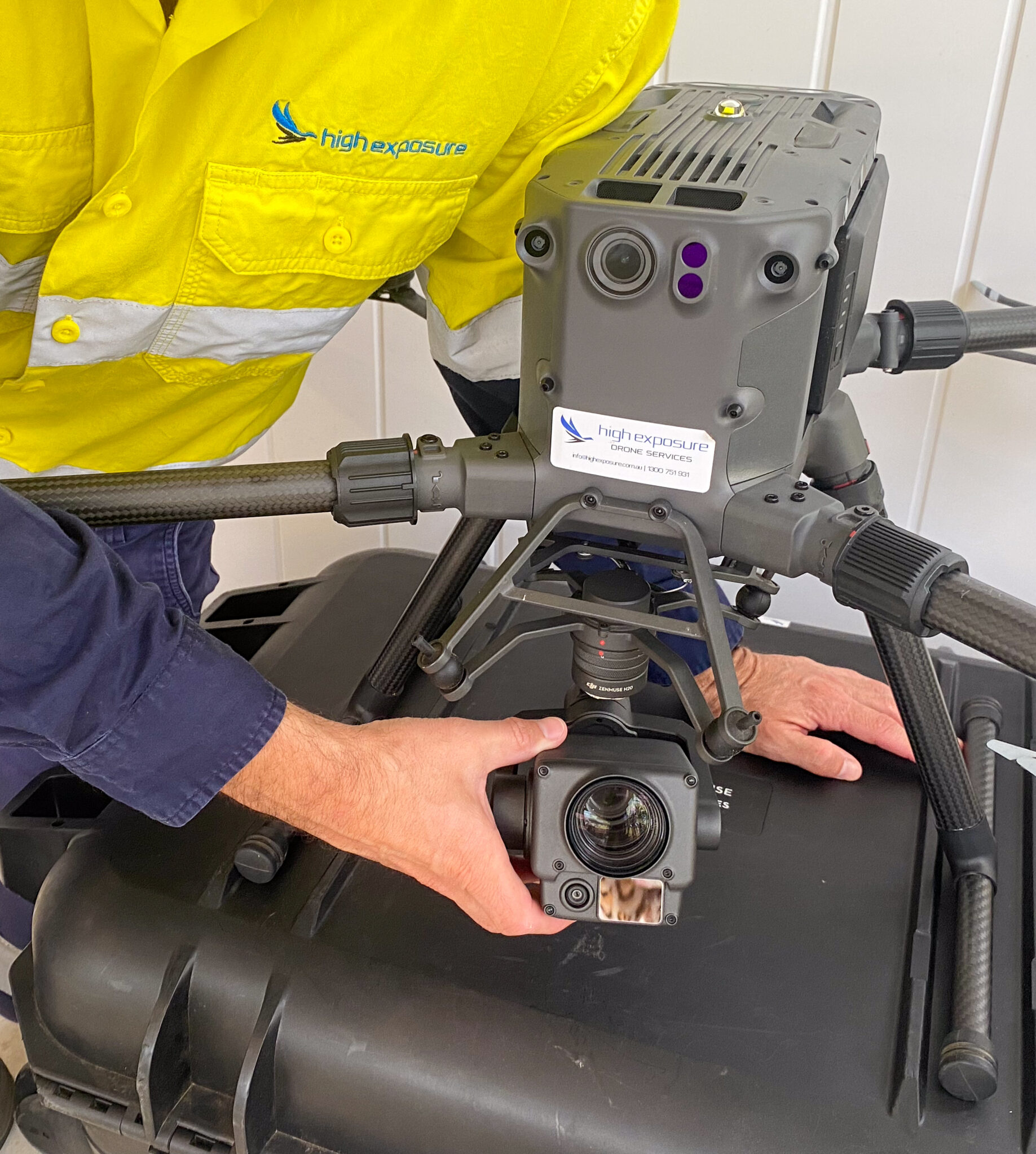
High Exposure is a CASA certified provider of remotely piloted aircraft inspection and surveying services.
Our aim is to provide clients with a complete, comprehensive and detailed visualisation of their site or asset enabling them to quickly and easily make informed decisions.
Utilising best in class aerial equipment and software to provide an accurate and contextual solution to your asset inspection requirements that will improve the way businesses monitor and maintain their assets
Operating out of Sydney, New South Wales and working with our extensive network of skilled technicians puts High Exposure in an ideal position to achieve your project objectives wherever they may be across Australia.
We provide a diverse range of solutions to meet our clients project requirements
Using optical and thermal camera sensors, our aerial systems are capable of close visual inspections of building roofs and facades to quickly spot defects such as leaks, damaged tiles, brick work, corrosion, concrete cancer, cracks & window structural issues.
Our bridge aerial inspections have proven their value time and time again by being able to reach places rope access and elevated work platforms can’t. High end zoom cameras allow high detailed imagery all all areas of the structure.
4G and 5G Mobile phone tower asset owners are always looking for ways to reduce inspections costs and time due to the vast number of towers throughout Australia. Drones are an ideal, fast and efficient method or completing these inspections. Issues such as corrosion, animal intervention, faulty wiring and missing bolts.
Other services such as line of sight surveys and site design visits are also useful in the telco industry for tower and site upgrades.
Drones have become an essential tool in power line inspections by transmission network managers with crucial data to make informed decisions. Our industrial RTK drones are immune to interference to allow safe flight. Zoom lenses allow high detail of the power line ad all its components such as cross members, phase conductors, insulators and missing bolts.
Drones are incredibly useful in inspecting solar farms due to the huge reduction in time while being able to provide both RGB and radiometric imagery in the same flight from the same sensor. Our aerial systems can spot module faults with cells as well as failures with diodes.
Mapping of an area can be undertaken quickly and efficiently to produce results with fast turnarounds. Highly accurate 2D and 3D mapping surveys are available meaning measurements and calculations can be taken from them. This service is popular with construction sites, quarries and real estate properties.
We can create high quality models of construction sites, properties, buildings or other infrastructure that provides a 3D view in great detail. A photogrammetry capture process that has been developed and refined is used to ensure a high quality product. These images are then processed to generate an interactive model that you are able to view on your computer or device.
Elevation data is essential for many industries and the creation of contour maps provides detailed information for our clients. Our drones use advances photogrammetry software.
Using industry leading drone photogrammetry software Pix4D, we are able to accurately measure stockpile inventory on site. The process is quick and extremely cost effective. A must have for any site dealing with large volumes of material.
We seek to deliver cost effective results for farmers, vineyard and golf courses owners. We can map hundreds of acres quickly and accurately for general crop monitoring and farm planning using aerial NDVI and RGB cameras.
Tracking the progress of a job site through regular photo and video has been documented as the number one use for drones in a commercial application from a recent industry survey. Site managers who use drones to track progress on construction sites say they can’t afford NOT to have the photo/video reports.
Taking progress reports a step further, a site manager can also monitor a particular event on site live online without actually being there. They can then communicate with people on site to give feedback and instruction.
The use of photogrammetry to create survey accurate representations of your site is an invaluable tool for all site managers. This data can be utilised for asset classification, construction validation as well as health and safety. In particular, a frequent mapping schedule provides a time series of the progress on a work site to identify new issues and mitigating risk rather than responding to it.
Enable your audience to engage with your brand or company from a unique and exciting perspective. We work with clients to understand their business to plan and produce a video that will accompany your marketing strategy.
Perfect for promoting products, golf courses, hotels or to provide a cinematic edge to display your business location. We will plan with your requirements and budget in mind to produce a commercially ready video for your business.
We have the equipment and experience to capture a wide array of events with our drones from cinematic displays to fast moving subjects.
The forward thinking industries in which we provide services who are embracing the future with High Exposure aerial survey & inspection services
The introduction of drones into the telco space has significantly improved the ability to deliver thorough and accurate data in a timely manner to facilitate the upgrade process of telecommunication towers and sites.
Tasks that facilitate this process that drones have the capability to complete include line of sight surveys (LoS), site design visits (SDV’s), antenna and tower inspections, cable feeder and other point to point measurements as well as accurate 3D models of towers and sites.
Using drones have become increasingly valuable tools in environmental management. They offer a range of capabilities that can enhance data collection, monitoring, and analysis in various environmental applications.
This ranges from accurate topographical land surveys, map creation in 2D and 3D, wildlife monitoring, crop, tree and weed monitoring and soil analysis, flood and fire damage assessments as well as erosion and coastal monitoring.
Various sensors can be used in this space from RGB, thermal, LiDAR, ground penetration radar and many others.
With the world moving towards a greener future, the solutions involve the implementation of large volumes of infrastructure such as solar farms, wind farms.
We have years of experience working with large construction companies to produce aerial surveys, progress reporting, asset inspections, surveys and also marketing content. We are able to conduct regular identical flights over your site to monitor change over times. Improve contributor and stakeholder collaboration by sharing data to anyone with an internet connection, or creating reports in PDF format.
The ongoing technological advancements in Architecture are undeniable. From sophisticated design software to electronic utilities and applications, Architecture is evolving into one of the most technologically adept professions globally. The integration of specific software has greatly simplified the process of mapping geographies. Thanks to Geographic Information Systems (GIS), site mapping and analysis have become more accessible than ever, with the use of Aerial Drones being a key factor in this simplicity.
The use of drones in mining leads to increased efficiency, reduced costs, enhanced safety, and better overall management of mining operations. The technology continues to evolve, offering even more advanced capabilities to further benefit the mining industry.
We provide a diverse range of solutions to meet our clients project requirements
Using optical and thermal camera sensors, our aerial systems are capable of close visual inspections of building roofs and facades to quickly spot defects such as leaks, damaged tiles, brick work, corrosion, concrete cancer, cracks & window structural issues.
Using optical and thermal camera sensors, our aerial systems are capable of close visual inspections of building roofs and facades to quickly spot defects such as leaks, damaged tiles, brick work, corrosion, concrete cancer, cracks & window structural issues.
Our bridge aerial inspections have proven their value time and time again by being able to reach places rope access and elevated work platforms can’t. High end zoom cameras allow high detailed imagery all all areas of the structure.
4G and 5G Mobile phone tower asset owners are always looking for ways to reduce inspections costs and time due to the vast number of towers throughout Australia. Drones are an ideal, fast and efficient method or completing these inspections. Issues such as corrosion, animal intervention, faulty wiring and missing bolts.
Other services such as line of sight surveys and site design visits are also useful in the telco industry for tower and site upgrades.
Drones have become an essential tool in power line inspections by transmission network managers with crucial data to make informed decisions. Our industrial RTK drones are immune to interference to allow safe flight. Zoom lenses allow high detail of the power line ad all its components such as cross members, phase conductors, insulators and missing bolts.
Drones are incredibly useful in inspecting solar farms due to the huge reduction in time while being able to provide both RGB and radiometric imagery in the same flight from the same sensor. Our aerial systems can spot module faults with cells as well as failures with diodes.
Mapping of an area can be undertaken quickly and efficiently to produce results with fast turnarounds. Highly accurate 2D and 3D mapping surveys are available meaning measurements and calculations can be taken from them. This service is popular with construction sites, quarries and real estate properties.
Mapping of an area can be undertaken quickly and efficiently to produce results with fast turnarounds. Highly accurate 2D and 3D mapping surveys are available meaning measurements and calculations can be taken from them. This service is popular with construction sites, quarries and real estate properties.
We can create high quality models of construction sites, properties, buildings or other infrastructure that provides a 3D view in great detail. A photogrammetry capture process that has been developed and refined is used to ensure a high quality product. These images are then processed to generate an interactive model that you are able to view on your computer or device.
Elevation data is essential for many industries and the creation of contour maps provides detailed information for our clients. Our drones use advances photogrammetry software.
Using industry leading drone photogrammetry software Pix4D, we are able to accurately measure stockpile inventory on site. The process is quick and extremely cost effective. A must have for any site dealing with large volumes of material.
We seek to deliver cost effective results for farmers, vineyard and golf courses owners. We can map hundreds of acres quickly and accurately for general crop monitoring and farm planning using aerial NDVI and RGB cameras.
Tracking the progress of a job site through regular photo and video has been documented as the number one use for drones in a commercial application from a recent industry survey. Site managers who use drones to track progress on construction sites say they can’t afford NOT to have the photo/video reports.
Tracking the progress of a job site through regular photo and video has been documented as the number one use for drones in a commercial application from a recent industry survey. Site managers who use drones to track progress on construction sites say they can’t afford NOT to have the photo/video reports.
Taking progress reports a step further, a site manager can also monitor a particular event on site live online without actually being there. They can then communicate with people on site to give feedback and instruction.
The use of photogrammetry to create survey accurate representations of your site is an invaluable tool for all site managers. This data can be utilised for asset classification, construction validation as well as health and safety. In particular, a frequent mapping schedule provides a time series of the progress on a work site to identify new issues and mitigating risk rather than responding to it.
Enable your audience to engage with your brand or company from a unique and exciting perspective. We work with clients to understand their business to plan and produce a video that will accompany your marketing strategy.
Perfect for promoting products, golf courses, hotels or to provide a cinematic edge to display your business location. We will plan with your requirements and budget in mind to produce a commercially ready video for your business.
We have the equipment and experience to capture a wide array of events with our drones from cinematic displays to fast moving subjects.
The forward thinking industries in which we provide services who are embracing the future with High Exposure aerial survey & inspection services
The introduction of drones into the telco space has significantly improved the ability to deliver thorough and accurate data in a timely manner to facilitate the upgrade process of telecommunication towers and sites.
Tasks that facilitate this process that drones have the capability to complete include line of sight surveys (LoS), site design visits (SDV’s), antenna and tower inspections, cable feeder and other point to point measurements as well as accurate 3D models of towers and sites.
Using drones have become increasingly valuable tools in environmental management. They offer a range of capabilities that can enhance data collection, monitoring, and analysis in various environmental applications.
This ranges from accurate topographical land surveys, map creation in 2D and 3D, wildlife monitoring, crop, tree and weed monitoring and soil analysis, flood and fire damage assessments as well as erosion and coastal monitoring.
Various sensors can be used in this space from RGB, thermal, LiDAR, ground penetration radar and many others.
With the world moving towards a greener future, the solutions involve the implementation of large volumes of infrastructure such as solar farms, wind farms.
Lorem ipsum dolor sit amet, consectetur adipiscing elit. Etiam pellentesque diam in eros vulputate, sit amet luctus metus auctor. Phasellus placerat erat dui, quis bibendum dui congue eu. Praesent nec malesuada tellus. Duis sed aliquam felis, nec fringilla eros. Mauris dui ligula, bibendum non sem a, mollis consequat nibh. Phasellus tristique risus ac metus facilisis pellentesque.
Duis ultrices tellus posuere tortor vehicula, id accumsan dui pretium. Vestibulum quis pulvinar erat, sed gravida dolor. Curabitur porttitor metus sit amet risus convallis, in lobortis leo luctus. Vivamus ullamcorper bibendum luctus. Nunc accumsan egestas erat, ut maximus lectus venenatis vitae. Mauris sed enim eleifend, euismod nulla quis, tristique lacus. Vestibulum sollicitudin molestie nisl id tincidunt.


Yes, we hold a remote pilot operators certificate (ReOC 6409) and able to operate anywhere within Australia. This enables us to apply for permits in restricted airspace as well as operate larger, more advanced remotely piloted aircraft
Drone regulations in Australia were managed by the Civil Aviation Safety Authority (CASA). Being a CASA licensed RPA (Remotely Pil0ted Aircraft) company, High Exposure has the capability to mitigate these restrictions depending on the circumstances.
As of 2022, some key points regarding drone regulations in Australia included:
Registration: Drone operators were required to register their drones with CASA if the drone weighed more than 250 grams.
Operator Accreditation: Remote pilots were required to obtain operator accreditation from CASA before flying their drones. This involved completing an online course and passing an exam.
Flyer Identification: Pilots were required to label their drones with their registration details. This information needed to be easily accessible without the use of tools.
No-Fly Zones: Certain areas, such as airports and emergency operation areas, were designated as no-fly zones. Drones were prohibited from flying in these areas without specific authorization.
Fly Below 120 Meters: Drones were generally required to be flown below 120 meters (approximately 400 feet) above ground level.
Visual Line of Sight: Pilots were required to maintain a visual line of sight with their drones at all times unless they had obtained a specific exemption from CASA.
Prohibited Operations: Certain activities were prohibited, including flying over people, flying at night without proper equipment, and flying in a way that creates a hazard to people, property, or other aircraft.
Liability Insurance: While not mandatory, it was recommended that drone operators have liability insurance.
Please note that these regulations were accurate as of January 2022, and there may have been updates or changes since then. Always refer to the latest information from CASA or other relevant authorities for the most current drone regulations in Australia.
High Exposure has the capability to provide drone services anywhere in Australia with help from their extensive list of experienced contractors.
Our team operating out of Sydney has been capturing aerial and spatial data since 2016, providing a wealth of knowledge and experience in the field. We have built proven methodologies and scopes of work for every scenario
Safety is our highest priority in all of our operations. We hold all required CASA licenses and insurance to ensure a smooth operation
Your project goal is our priority. Our team of passionate professionals will work with you to ensure we get a result that solves your questions
High Exposure was engaged by the main contractor overseeing the remedial repairs of Australian National University in Canberra to assist with assessing damages to a
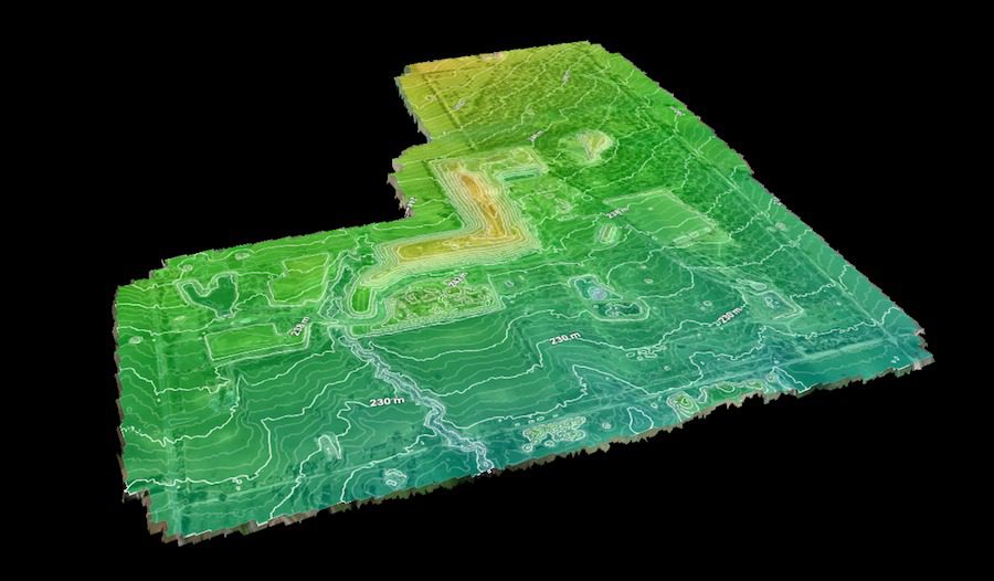
High Exposure Commercial Drone Services undertook an aerial survey at the 250-hectare Gregadoo Waste Management Facility, employing drone photogrammetry and LiDAR capture techniques. The primary
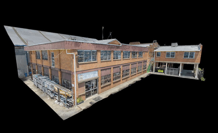
High Exposure was engaged to undertake a significant project to create a high-resolution aerial photogrammetry 3D model for a thorough inspection of brickwork on the